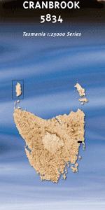
TAS 5834 – Cranbrook For Sale
- Estimated Delivery : Up to 4 business days
- Free Shipping & Returns : On all orders over $200
This Topographic Map is produced by the Department of Primary Industries, part of the Tasmanian Government.
These maps are an important resource for Government, industry, and the public. They are used for environmental and emergency management, farm planning and mineral exploration. They are also popular for recreational users such as bushwalkers, mountain bike and horse riders.
The PDF version of this can be printed at home or sent to a professional printer for a 100% scale reproduction.
At this scale, 4cm on this map represents 1km on the ground. A standard map (which is square) covers an area of approximately about 12.5km by 12.5km, with a contour interval of 10m. This map contains natural and constructed features including road and rail infrastructure, vegetation, hydrography, contours, localities and some administrative boundaries.
Glen Gala Milton Cranbrook House Craigie Knowe Melrose Spring Vale Trangie The Grange The Springs Riversdale Belmont The Bend Double Culvert Creek Barkstand Point Barney Wards Bay Barney Wards Lagoon Barneys Bluff Bayles Backwater Bayles Point Big Punchbowl Black Swamp Blue Spur Bluemans Creek Bluemans Valley Boathouse Gully Bottom Bank Breakfast Point Campbells Bank Channel Junction Cherry Tree Lagoons Cranbrook Dam Gully Didos Hill Grange Hills Grassy Point Gravelly Hill Greasy Pole Reach Glen Gala Creek Gum Tree Hole Hardstruggle Gully Haystack Point King Bay Kit Owen Creek Little Bay Little Punchbowl Long Point Majors Creek Middle Bank Moulting Lagoon Moulting Lagoon Game Reserve Peacocks Creek Pelican Island Pelican Rocks Plains Creek Plains Swamp Point Meredith Raynors Gully Reedy Duckhole Sabinas Island Serpentine Lagoon Sherbourne Bay Swan Cut Swan Nook Watsons Bay Whelans Bridge White Rock Bay Woolshed Point Yellow Sandbanks Big Sand Hole Bloomer Creek Bluemans Creek Bridge Bluemans Valley Bridge Bottom Hole Castle Bridge Cygnet River Bridge Freestone Creek Bridge Little Sand Hole Middle Hole Opening Hole Round Hole Secret Hole Sherbourne Holes Wye River Bridge Yards Hole Brushy River Great Swanport Great Swan Swanport Wye River Swan River Wyefield Rivulet OConnor Rivulet
| Title | Pdf Download |
|---|