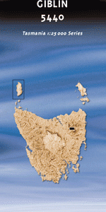
TAS 5440 – Giblin Online
- Estimated Delivery : Up to 4 business days
- Free Shipping & Returns : On all orders over $200
This Topographic Map is produced by the Department of Primary Industries, part of the Tasmanian Government.
These maps are an important resource for Government, industry, and the public. They are used for environmental and emergency management, farm planning and mineral exploration. They are also popular for recreational users such as bushwalkers, mountain bike and horse riders.
The PDF version of this can be printed at home or sent to a professional printer for a 100% scale reproduction.
At this scale, 4cm on this map represents 1km on the ground. A standard map (which is square) covers an area of approximately about 12.5km by 12.5km, with a contour interval of 10m. This map contains natural and constructed features including road and rail infrastructure, vegetation, hydrography, contours, localities and some administrative boundaries.
Camelford North Whisloca Carr Villa Abrahams Creek Adams Hill Big Ben Creek Big Opening Blacksnake Marsh Borrowdale Brady Kayes Lookout Braemar Creek Castle Hill Cigar Rocks Circinus Peaks Coalmine Crag Cow Plain Daisy Flat English Town Ford River Giblin Fells Giblin Peak Hamilton Crags Icehouse Creek Island Creek Jacobs Ladder Joy Falls Kangaroo Hills Kangaroo Plain Land Of Little Sticks Legges Tor Little Hell Markham Heights Meadow Vale Menamatta Tarns Misery Bluff Normans Folly Old Bills Monument Old Mill Creek Phillips Creek Piesse Vale Pig Run Creek Plains of Heaven Ragged Jack River O Plain Creek Roses Tier Satans Gully Sprent Plains Stein Crags Stonjeks Lookout Strickland Gorge Summit Pass Surprise Vale Tier Creek Upper Blessington Watchtower Wattle Corner Whymper Crags Youls Sugarloaf Big Ben Slope Cooters Layout Echo Rocks Ewerts Course Little Hell Slope Little Slalom Course Lohreys Shelf Manns Creek Mitchells Run Organ Pipes Pig Run Creek Bridge River O Plains Creek Bridge Smithies Run Strickland Rise Thirty Seconds Slope Wattle Corner Gully Blessington Upper River OPlains Creek Bridge Burns Creek Burn Creek Blessington OPlain Creek Legge Peak
| Title | Pdf Download |
|---|