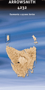
TAS 4232 – Arrowsmith Online
- Estimated Delivery : Up to 4 business days
- Free Shipping & Returns : On all orders over $200
This Topographic Map is produced by the Department of Primary Industries, part of the Tasmanian Government.
These maps are an important resource for Government, industry, and the public. They are used for environmental and emergency management, farm planning and mineral exploration. They are also popular for recreational users such as bushwalkers, mountain bike and horse riders.
The PDF version of this can be printed at home or sent to a professional printer for a 100% scale reproduction.
At this scale, 4cm on this map represents 1km on the ground. A standard map (which is square) covers an area of approximately about 12.5km by 12.5km, with a contour interval of 10m. This map contains natural and constructed features including road and rail infrastructure, vegetation, hydrography, contours, localities and some administrative boundaries.
Arrow Tarn Battle Creek Battle Ridge Bayeux Bluff Beehive Canal Beehive Creek Burns Creek Burns Dam Burns Plains Calders Lookout Calders Shelf Church Peak Clark Dam Divide Creek Dolly Hill Domesday Bluff Eucryphia Lead Griffiths Creek Godwin Tarn Guelph Basin Guelph Narrows Guelph River King William Creek King William Levee King William Plains King William Saddle Lake Adela Lake Arlette Lake Eva Lake George Lake King William Lake Sally Jane Lake Vincent Loddon Range Mary Ann Creek McKays Peak Middle River Milligans Peak Mount Arrowsmith Mount Harold Mount King William I Mount Pitt Mount Ronald Cross Needle Rock Tarn Norman Bluff Odo Tarn Rouen Tarn Sassafras Shore Scoparia Lake Shirleys Pool Squires Creek Surprise River Switchyard Bay Taffys Creek The Beehive Wessex Tarn Camp Creek Frankland Range Haldane Peak King William Creek Bridge Navarre River Bridge South Peak Taffys Creek Bridge The Divide Navarre River Mount King William Island Rufus River
| Title | Pdf Download |
|---|