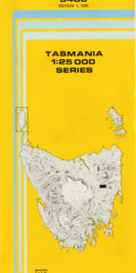
TAS 5436 – Diamond Cheap
- Estimated Delivery : Up to 4 business days
- Free Shipping & Returns : On all orders over $200
This Topographic Map is produced by the Department of Primary Industries, part of the Tasmanian Government.
These maps are an important resource for Government, industry, and the public. They are used for environmental and emergency management, farm planning and mineral exploration. They are also popular for recreational users such as bushwalkers, mountain bike and horse riders.
The PDF version of this can be printed at home or sent to a professional printer for a 100% scale reproduction.
At this scale, 4cm on this map represents 1km on the ground. A standard map (which is square) covers an area of approximately about 12.5km by 12.5km, with a contour interval of 10m. This map contains natural and constructed features including road and rail infrastructure, vegetation, hydrography, contours, localities and some administrative boundaries.
Brookdale Howley Lodge Duckhole Point Eastbourne Sugarloaf Athol Brae Back Rocky Hill Boomer Gully Campbell Town Mountain Carpenters Gully Cobbs Hill Davidsons Hills Den Hill Diamond Hills Englishmans Gully Ewe Run Hill Front Rocky Hill Gallows Hill Glenmay Creek Guidons Bottom Kangaroo Hill Kearneys Hill Llewellyn Creek Mulberry Hill New Year Hill Peacock Hill Rose Park Salisbury Rivulet Scotts Lagoons Slaters Gully Staircase Ford Staircase Gorge Stynes Creek Blanchards Creek Bridge Bonner Creek Campbell Town Saddle Campbell Town Tiers Round Marsh Taylors Hill The Island The Sisters Black Snake Marsh
| Title | Pdf Download |
|---|